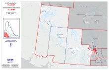
Overview Maps
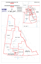
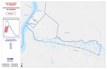
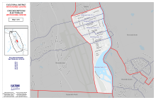
Map of the Yukon's electoral districts
This map shows all of the electoral districts in the Yukon.
Image
|
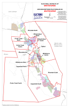
Map of Whitehorse electoral districts
This map shows the electoral districts in Whitehorse and the surrounding area.
Image
|
District Maps
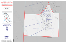
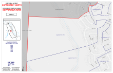
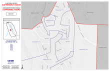
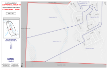
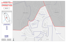
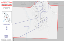
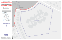
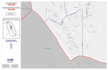
Map of Copperbelt North
Copperbelt North comprises the southern portion of the Copper Ridge subdivision. It is the 3rd smallest electoral district in Whitehorse at 3.6 km².
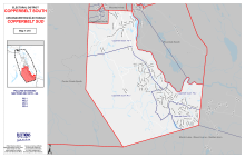
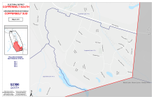
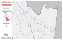
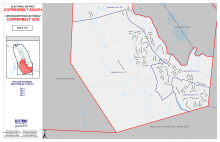
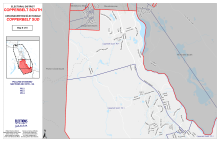
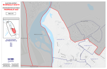
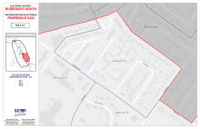
Map of Copperbelt South
Copperbelt South includes the subdivisions of Lobird, McLean Lake, Ear Lake Road, Canyon Crescent, Mount Sima, MacRae, Wolf Creek, Fox Haven, Pineridge, Spruce Hill, Mary Lake, Cowley Creek, and Whitehorse Copper, and it extends south to Km 1405 on the Alaska Highway. It is the 2nd largest electoral district in Whitehorse at 123.2 km².
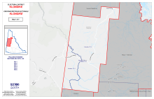
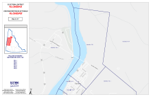

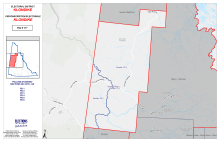
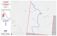
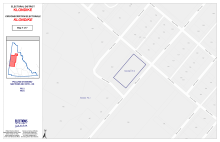
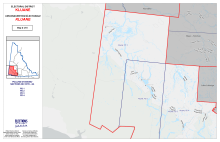
Map of Klondike
Klondike consists of Dawson City and the surrounding area, Forty Mile, Sixty Mile, Bear Creek, Rock Creek, Tombstone National Park, and Eagle Plains. It is the 3rd largest electoral district at 70,899 km2. It is the oldest electoral district in Yukon.
Image
| |||
Image
Polling Division 1 Map | Image
Polling Division 2 Map | Image
Polling Division 3 Map | Image

Polling Division 4 Map |
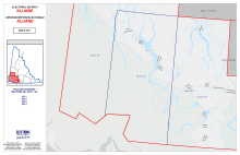
Map of Kluane
Kluane includes the communities along the Alaska Highway of Mendenhall, Haines Junction, Burwash Landing, Destruction Bay, Aishihik, Champagne, and Beaver Creek. The border between the Kluane electoral district and the Lake Laberge electoral district is Km post 1459 on the Alaska Highway. It is the 5th largest electoral district at 67,943 km².

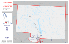
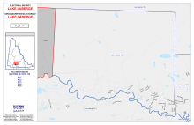


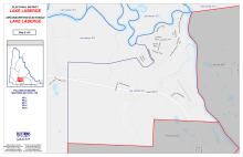
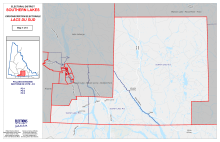
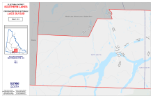
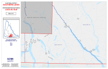
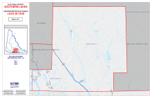
Map of Lake Laberge
Lake Laberge consists of communities along the North Klondike Highway, including Hidden Valley/MacPherson (Whitehorse subdivisions), the Mayo Road, Grizzly Valley, and Lake Laberge as far as Braeburn Lodge, as well as Takhini Hot Springs Road, Takhini River Road, Pilot Mountain, Ibex Valley, and Forestview (Cousins Airstrip Road). This is the 2nd smallest electoral district outside of Whitehorse at 14,450 km².
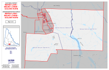
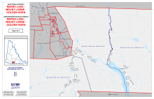
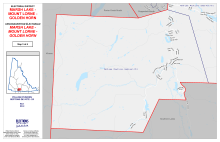
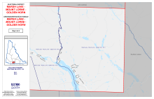
Map of Marsh Lake-Mount Lorne-Golden Horn
Marsh Lake-Mount Lorne-Golden Horn includes the communities of Marsh Lake, Little Squanga, Mount Lorne, Golden Horn, the Carcross Cutoff area, Annie Lake Road, Lewes Lake, and the Robinson subdivision. This is the smallest electoral district outside of Whitehorse at 4,460 km².
Image
| ||
Image
Polling Division 1 Map | Image
Polling Division 2 Map | Image
Polling Division 3 Map |
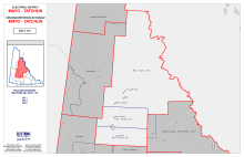
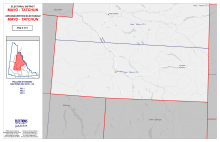
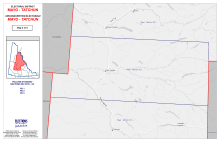
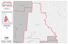
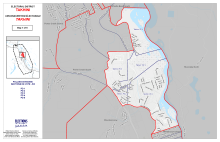
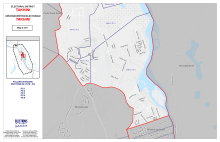
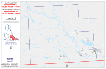
Map of Mayo-Tatchun
Mayo-Tatchun includes the communities of Mayo, Carmacks, Little Salmon, Pelly Crossing, Keno, Elsa, Stewart Crossing, Fort Selkirk, Drury Creek, and Silver Trails. It is the largest electoral district in the Yukon at 129,275 km².
Image
| |||
Image
Polling Division 1 Map | Image
Polling Division 2 Map | Image
Polling Division 3 Map | Image
Polling Division 4 Map |
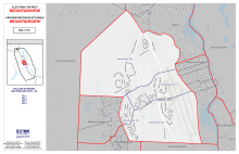
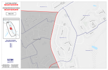
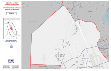
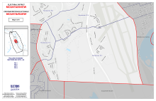
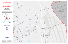
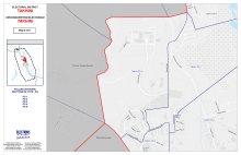
Map of Mountainview
Mountainview includes subdivisions of Valleyview, McIntyre, Hillcrest, and Granger and extends to the Copperbelt South electoral district (Km 1421), bounded by the Alaska Highway and the Two Mile Hill to the escarpment. It is the 7th largest electoral district in Whitehorse at 12.6 km2.
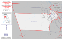
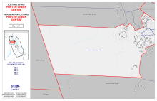
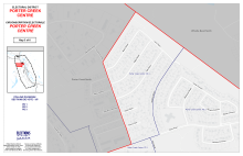
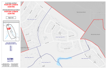
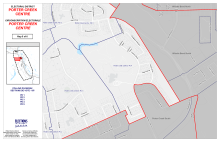
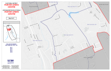
Map of Porter Creek Centre
Porter Creek Centre It includes the Kulan Industrial Area, the western portion of the Alaska Highway to Wann Road to east of Sycamore Street, north to the southern boundary of the Taylor Industrial Area, bounded by the Whistle Bend North border to Tamarack Drive (46-96), Hickory Street to south of Hemlock Street, the northern portion of 12th Avenue, and including Centennial Street to the Alaska Highway, then to the Alaska Highway to north of Raven’s Ridge and out to the municipal boundary. It is the 5th largest of Whitehorse's electoral districts at 21.1 km2.
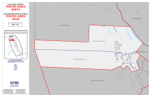
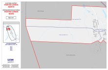
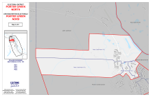
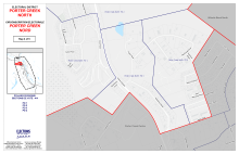
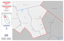
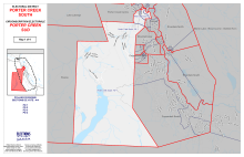
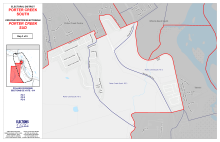
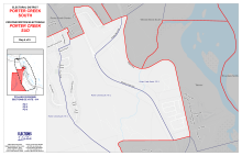
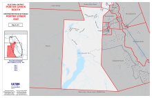
Map of Porter Creek North
Porter Creek North covers the northern boundary at km 1435 and includes Crestview and the Taylor Industrial area and is bounded by Sycamore Street, the north side of Wann Road, the east side of the Alaska Highway, and across to the north of the Kulan Industrial area, extending to the municipal boundary. It is the 6th largest of Whitehorse's electoral districts at 16 km2.
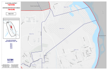
Map of Porter Creek South
Porter Creek South is south of the Range Road extension, the intersection of Range Road and Whistle Bend Way south on Range Road south of Northland Mobile Home Park, west of Yukon University, south to the intersection of the Alaska Highway, south of the Kopper King Mobile Home Park to include Raven’s Ridge, Fish Lake Road, and north and extending to the municipal boundaries. It is the largest of Whitehorse's electoral districts at 210 km2.
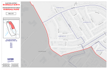
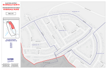
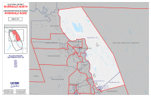
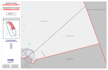
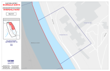
Map of Riverdale North
Riverdale North includes Long Lake Road, the western boundary of the Yukon River to Lewes Boulevard, east on Klondike Road to Peel Road, southwest on Alsek Road to Hyland Crescent, northeast on Pelly Road, and across to the municipal boundaries to abut the Lake Laberge electoral district. It is the 3rd largest electoral district in Whitehorse at 85.2 km².
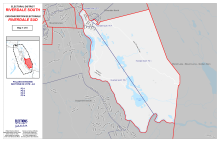
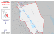
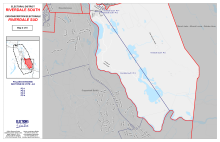
Map of Riverdale South
Riverdale South includes the southern portion of Lewes Boulevard, Klondike Road, southwest Peel Road, Pelly Road, northwest Alsek Road and Hyland Crescent, the Chadburn Lake Road, and south to the municipal boundary where it joins the Yukon River to abut the Copperbelt South electoral district. It is the 4th largest electoral district in Whitehorse at 58.9 km2.
Image
| ||
Image
Polling Division 1 Map | Image
Polling Division 2 Map | Image
Polling Division 3 Map |
Map of Southern Lakes
Southern Lakes includes the communities of Carcross, Jake’s Corner, Tagish, Johnson’s Crossing, Teslin, Crag Lake, and the Atlin Road area. This is the 6th largest electoral district at 28,329 km2.
Map of Takhini
Takhini is bounded by the Yukon River to the east and includes the eastern side of Range Road to the south of Northland Mobile Home Park across to the west to include the Yukon University area on the southern side and south to the Alaska Highway to the Two Mile Hill and the eastern side of the escarpment to Ogilvie Street. It is the 8th largest Whitehorse electoral district at 7.2 km2.
Image
|
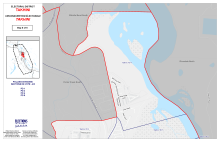
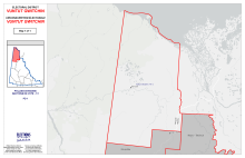
Map of Vuntut Gwitchin
Vuntut Gwitchin consists of the community of Old Crow, Vuntut National Park, Ivvavik National Park, Herschel Island, and part of the Dempster Highway. It is the fourth-largest electoral district at 70,530 km2. It is also one of the least populated electoral districts in any provincial or territorial legislature in Canada, with fewer than 200 ballots cast in any territorial election to date.
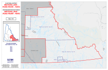
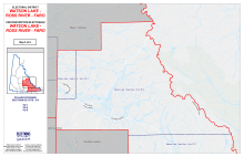
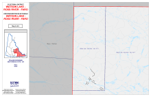
Map of Watson Lake-Faro-Ross River
Watson Lake-Faro-Ross River includes the communities of Watson Lake, Faro, and Ross River (previously part of the Pelly-Nisutlin electoral district), Upper Liard, Swift River, and Rancheria. They are linked by the Robert Campbell Highway. It is the 2nd largest electoral district at 98,861 km2.
Image
| ||
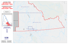
Image
Polling Division 1 Map | Image
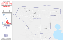
Polling Division 2 Map | Image

Polling Division 3 Map |
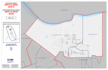
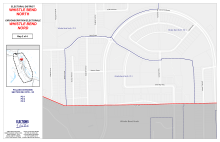
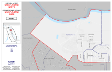
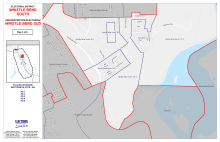
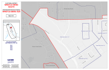
Map of Whistle Bend North
Whistle Bend North is north of Eldorado Drive, on the north side of Keno Way, and includes new developments on the western side. Whistle Bend North extends west to encompass a small part of Porter Creek North on the Whistle Bend side. It is the 4th smallest electoral district at 3.6 km².
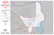
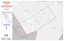
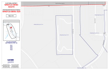
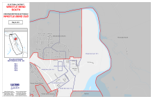
Map of Whistle Bend South
Whistle Bend South includes all of Eldorado Drive, the south side of Keno Way, and the Mountain View Golf Course. It is the 5th smallest electoral district at 3.6 km².
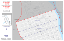
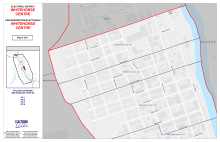
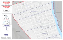
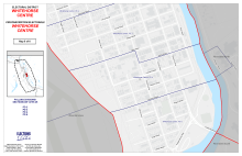
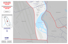
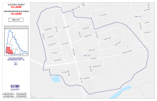
Map of Whitehorse Centre
Whitehorse Centre is bounded by the Yukon River and the south side of Ogilvie Street, following the escarpment to the Whitehorse Power Plant. It is the 2nd smallest electoral district at 2.4 km².
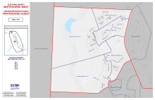
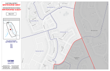
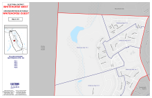
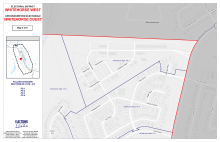
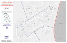
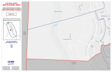
Map of Whitehorse West
includes the subdivisions of Ingram, Arkell, and Logan; the north part of Copper Ridge bounded by Lazulite Drive to Tigereye Crescent, cutting across to the north of Ruby Lane, and extending to the boundary of the Porter Creek South electoral district. It is the smallest electoral district in Whitehorse at 2.4 km².